(Executive summary) (Return to main page) (splitlining pictures for all 50 states)
The advantage of having our simple splitting algorithm draw the congressional districts is obvious. There is one and only one drawing possible given the number of districts wanted, the map of the state, and the distribution of people inside it. Which of those people are Liberal, Conservative, Republican, Democrat, Black, White, Christian, Jewish, polka-dotted, or whatever has absolutely zero effect on the district shapes that come out. So you know the maps are going to be completely unbiased. Get politicians to draw the maps and you know that not only are they going to be completely biased, they are also going to be a heck of a lot more complicated-shaped and they are going to use up a lot of your taxpayer money figuring out how to best-rob you of your vote. Which do you prefer? It has been over 200 years. Isn't it time to make gerrymandering a thing of the past?
Asterisk: If anybody's residence is split in two by one of the splitlines (which would happen, albeit very very rarely) then they are automatically declared to lie in the most-western (or if line is EW, then northern) of the two districts.
C.G.P. Grey's 3.5-minute youtube video attempting to describe the shortest splitline method.
High-precision computer-generated pictures for all 50 states, with commentary and analysis.
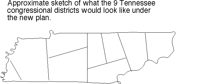
Tennessee's 9 congressional districts (pdf; as they were in 2004) Don't you love the incredibly gerrymandered shapes of districts 3 and 7? (No House member from Tennessee ever lost a bid for re-election during 1980-2005.)
Great. Now compare with our approximate sketch (png fastest) (tiff second best) (pdf third) (ps) of how they'd instead look as drawn by our completely bias-free automatic splitting algorithm.
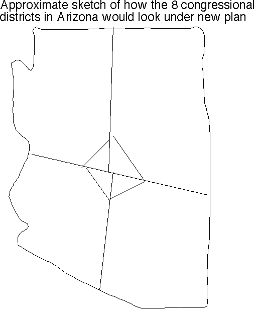
Arizona's 8 congressional districts (pdf; as they were in 2004) Yes! We have a new champion for most incredible gerrymander: district 2.
Great. Now compare with our approximate sketch (png fastest) (tiff second best) (pdf) (ps) of how they'd instead look as drawn by our algorithm.
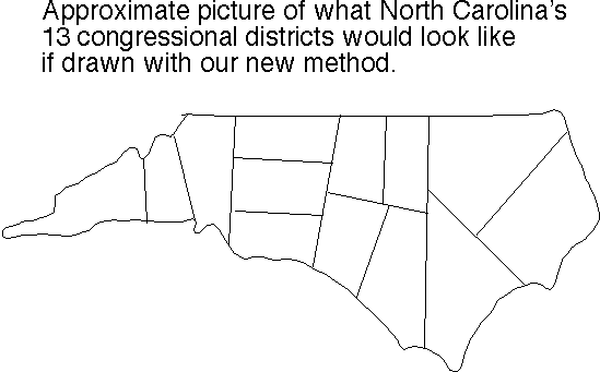
North Carolina's 13 congressional districts (pdf; as they were in 2004); love that district 12, and hello, district 3 actually is divided into two or three pieces since it goes out to sea and comes back to land! Or maybe two of them are connected at low tide? (Was that what Paul Revere had in mind when he said "one if by land, two if by sea"?) And ooh, check district 1!
Great. Now compare with our approximate sketch (png fastest) (tiff second best) (pdf) (ps) of how they'd instead look as drawn by our algorithm.
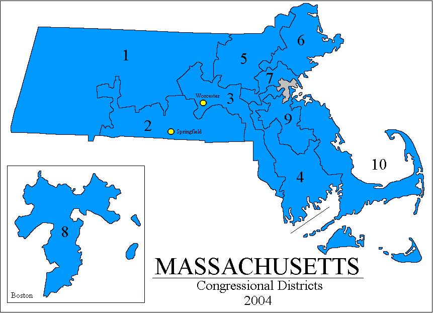
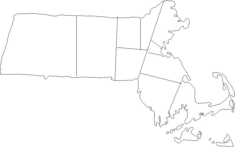
Massachusetts''s 10 congressional districts (map from Adam Carr's Psephos archive) (gif fastest) (png middle) (jpg slowest) versus approximate sketch of how it would look redrawn with our algorithm: (png fastest) (jpg slower) It was Massachusetts governor Elbridge Gerry who is credited with inventing gerrymandering in 1812. He was voted out of office immediately by outraged voters, but his legacy evidently lives on. Massachusetts has 100% Democratic congressmen and has for at least the last three election cycles, despite having a Republican governor (you can't gerrymander the governor race, since it is a statewide election). Here's a Boston Globe Editorial on the subject.
Texas's 32 congressional districts (side-by-side comparative chart from the Associated Press as printed in the Houston Chronicle 9 Oct. 2003) showing district shapes before and after the extraordinary redistricting in 2003. (jpg) (And here [png] is a closeup on what they did to Austin to split up those annoying Austin voters.) The gerrymandering was not inconsiderable before the redistricting, e.g. check district 4 near Dallas. But, after it – after it – aaah, for total statewide brazenness Texas really takes the cake. Check district 19 (Lubbock in the north West) and the whole East half of the state is made of those long thin districts. And for extra amazement check those closeups on Houston, and Tom DeLay's personal district 22. Yup, definitely Texas is an unbelievable new champion. (Check the 127-page Texas Court decision declaring this totally legal. Before re-gerrying: Texas had 17 Democrat and 15 Republican congress. After, it was 11-to-21 the other way. Christian Science Monitor editorial on this.)
(You can make your own sketch of what Texas would look like with the new scheme. Have fun. Much nicer, no?)
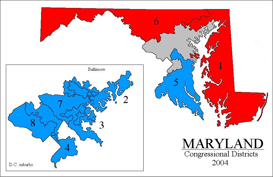
Maryland's 8 congressional districts (gif; as they were in 2004). Holy sea of rattlesnakes Batman! Numerous go out to sea and come back to land districts, amazingly squirelly boundary shapes. Here's approximately how it would look redistricted via shortest splitline (png).
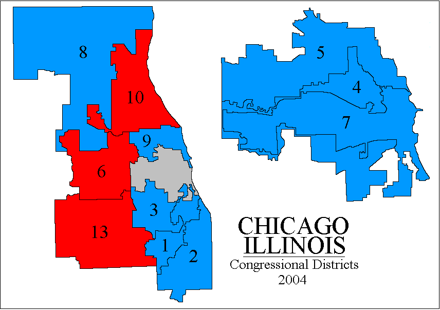
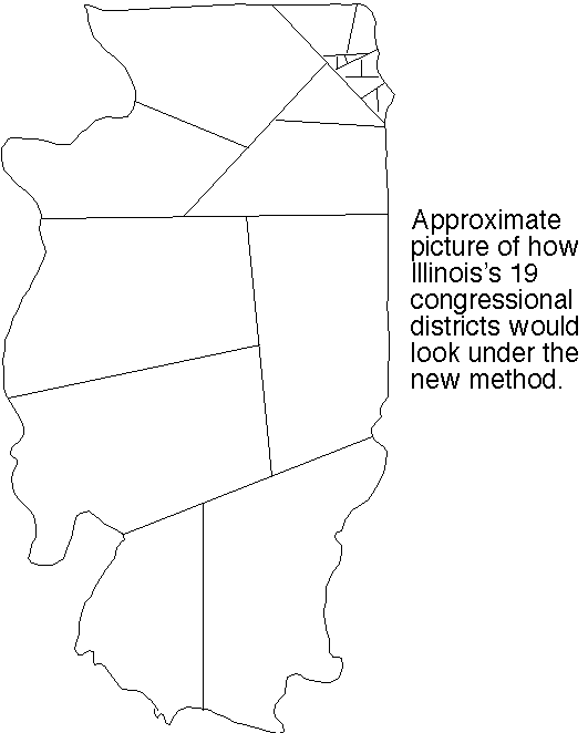
Illinois' 19 congressional districts (pdf; as they were in 2004). Wow. I thought Texas was bad, but Illinois may be the new champ. District 17 is just awesome. But then again districts 19, 15, and 11 are no slouches. You cannot actually see a lot of the small Chicago districts without a magnifying glass, so here is a closeup view (gif) [this picture is from Adam Carr's psephos database] color coded by party control in 2004. Districts 1, 10, 8, 5, and 7 are pretty bad, but district 4 is a wowser! (Notice it looks pretty bad... but then you realize it actually continues west past the point you thought it had ended... going along a thin strip lying entirely inside a highway... which loops around until expanding to enclose a second bad-looking region.)
Great. Now compare with our approximate sketch (png fastest) (tiff second best) (pdf) (ps) of how they'd instead look as drawn by our algorithm.
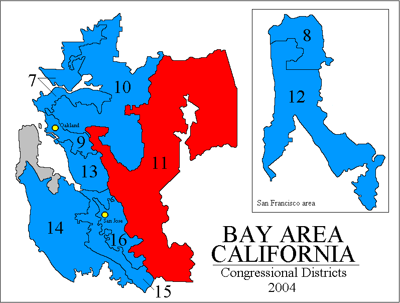
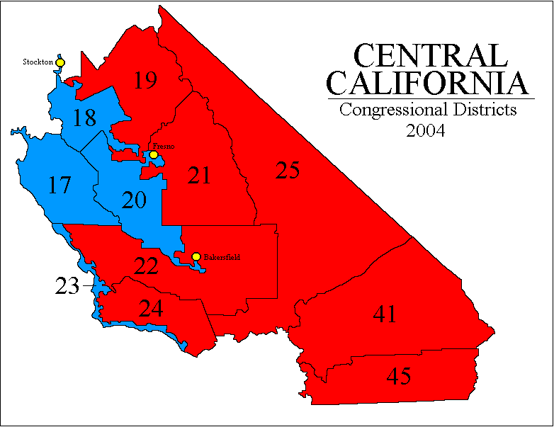
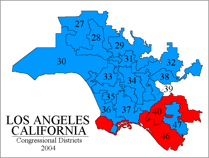
California? In 2004, not one of CA's 173 state legislative and federal congressional seats changed party-hands. In 2002, every incumbent won re-election, on average with 69% of the vote. California may be the new gerrymandering champion, perhaps even worse than Illinois and Texas, but unlike them its gerrymandering is "bipartisan" that is, arranged by agreement among the Democrats and Republicans to "design their own districts" to make every office holder "safe." (Later note: see this about the new random-commission system CA adopted in 2010-2011!) ( Specifically, CA state law causes any redistricting not approved by at least 2/3 of the state legislature to be challengeable by the voters in a referendum. That forces the Democrats in control of California to gerrymander for at least some Republican legislators too. Republican Assemblyman Roy Ashburn, vice-chair of the redistricting committe, told the San Diego Union-Tribune in May 20-01 "I think it is very possible... we can achieve a bipartisan redistricting... it takes openness and willingness to compromise." And indeed the deal that was struck was to protect almost all incumbents from both parties, allowing Democrats to keep all their seats but also the Republicans could do so, plus the Democrats would draw one new district – mandated by population growth – in such a way that they would get that new one too. Only a few were troubled by the result, e.g. Republican Assemblyman Tim Leslie told the LA Times "We won't have to worry about elections for six, eight, ten years because [the districts] are all pre-set. Everybody wins... What happened to drawing lines for the people of the state rather than ourselves?" ) The devil's jigsaw puzzle (gifs from Adam Carr's psephos database): Northern Calif, Calif Bay Area, Central Calif, Los Angeles area, Southern Calif. All of Los Angeles is amazing but district 53 in Southern Calif. (San Diego) is especially neat since it actually goes out to sea and comes back to land.
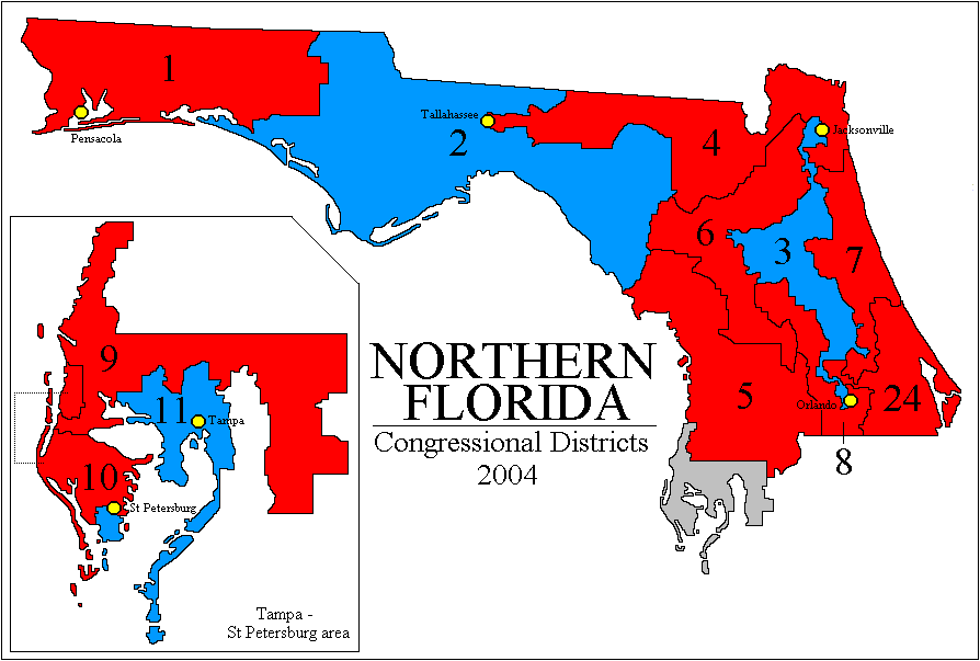
Florida? Holy cow, Florida (especially Eastern) may be even worse than California! (color pdf), (Northern FL, gif from Psephos), (Southern FL, gif from Psephos with closeups). The district 22 & 23 tandem team is just beyond belief trying to neutralize as many Democrats as possible so that Florida as a whole can be safely massively Republican-dominated; you really need the closeup map to see its full glory. [Alcee Hastings, an impeached Federal judge convicted of multiple counts of bribery, was re-elected by the 23rd. Gee, I wonder why.]
Many more US state district maps at Wikipedia (jpgs); Ohio, Massachusetts, Oklahoma, and Pennsylvania all are amazing. And http://www.melissadata.com/lookups/mapCD.asp gives you district maps on demand – but I just tried it for my New York district 1 and it was not a very good drawing.
Colorado? The New York Times found a non-gerrymandered district there and expressed incredulity.
And here's a USA Gerrymandering art gallery (gifs).
"There is no issue that is more sensitive to politicians of all colors and ideological persuasions than redistricting. It will determine who wins and loses for eight years." – Ted Harrington, political science chair, UNC-Charlotte, quoted during Shaw v. Hunt trial, March 1994
Only two things are infinite, the universe and human stupidity, and I'm not sure about the former. – Albert Einstein
Yes, but they are tiny compared to its benefits. Our district shapes ignore geographic features such as rivers and highways, and political features such as country boundaries inside state maps. As you can see from the example-pictures above, the old approach of politicians drawing districts sometimes used those things, sometimes misused them, and other times conveniently ignored them, all with the principal aim of maximally denying you fair representation.
The advantage of having a purely mathematical definition of the district shapes is that there is absolutely no room whatsoever for bias or any freedom of choice at all by district drawers. That shuts the gerrymanderers down. Period.
We admit you may pay a small price for this, both financially, and occasionally (in some areas) in convenience. But the financial price is tiny compared to the amount you will save from having a less-corrupt, more democratic government. And actually, considering you'll no longer have to pay an unwanted small army of super-biased nerds to figure out how to draw and print those crazy maps, all lot of money will actually be saved with our scheme. In 2001, California State Democrats paid political consultant Michael Berman $1.36 million to draw the US House district map for California, with incumbent Democratic members of Congress paying him collectively about $600,000. "Twenty thousand is nothing to keep your seat," Democratic Congresswoman Loretta Sanchez told the Orange County Reporter. "I spend $2 million [campaigning] every election. If my colleagues are smart, they'll pay their $20,000 and Michael will draw the district they can win in. Those who have refused to pay? God help them." See chapter 1 of Overton's book for this story. In contrast, our high-res computerized splitline districting computation for all 50 states combined cost us approximately 10 cents worth of electricity and less than 1 day worth of time. And the inconvenience will usually actually be "convenience" because it will be much easier to figure out which district you are in if the maps are simple, as opposed to looking like a salamander-octopus mutant diseased with severe hives.
Gerrymandering can lead to self-reinforcing one party domination.
Cross-country survey – which countries seem the best and the worst as far as gerrymandering is concerned? And how do they do it?
Do "independent" or "bi-partisan" district-drawing commissions work?
The (somewhat related) fraudfactor.com site.
![here [png]](TXtravis24.png)